

A University of Mary Washington student and a professor have created a map featured at the Fredericksburg Area Museum showcasing the travels of Lafayette in America.
by Lisa Chinn Marvashti
UNIVERSITY OF MARY WASHINGTON
University of Mary Washington senior Brooke Prevedel and Professor of Geography Steve Hanna spent more than 100 hours making the map at the center of a new Fredericksburg Area Museum exhibit.
“I spent most of my time hunched over my drawing tablet looking at it in extra blown-up proportions,” said Prevedel, a historic preservation and classical archaeology double major who’s earning a certificate in GIS.
High-tech tools like her tablet, and computer programs and apps, helped the pair create the map, which shows the 1824 journey of the Marquis de Lafayette through America’s 24 states. But meticulous attention to detail – like the mountain ranges Prevedel cranked out by hand for a fountainpen feel – tell a story they hope will take visitors back to the 19th century.
“It’s exactly what I was hoping for, but I think it’s even cooler than I imagined,” FAM Curator of African American History and Special Projects Gaila Sims said of the map, part of a two-year exhibit titled “Lafayette’s World: Revolutionary Ideals and the Limits of Freedom.”
At 48 inches wide and 60 inches tall, it’s one of the largest print maps Hanna has tackled. And that’s saying a lot. An American Association of Geographers (AAG) cartography editor, his decades of bringing terrains and topographies to life have made him, Prevedel said, a “wizard” at map-making.
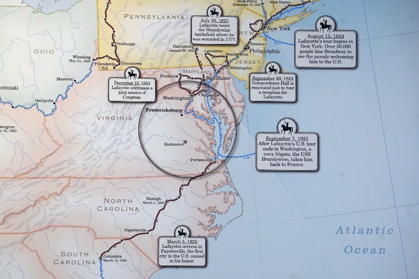
Prevedel and Hanna created the map showing Lafayette’s journey through the United States using a mix of high-tech tactics and tried and true techniques. Prevedel drew the mountain ranges by hand using a tablet. Photo by Suzanne Carr Rossi.
That’s what led Sims, who became acquainted with his work while in grad school, to turn to Hanna, who turns often to students. He tapped Prevedel, who had worked alongside him as an AAG editorial assistant and on signage for the Fredericksburg Civil Rights Trail.
“This wasn’t going to be introductory work,” Hanna said of the project, of which they are co-authors, with Prevedel – who used it also as her GIS capstone – receiving top billing.
Together, they found a base map and began layering on details, like lakes and streams. But the features didn’t always line up, so they set about adjusting state boundaries and editing coastlines. When “hillshading,” a cartographic method of depicting mountains, wouldn’t work for such a large project, Prevedel resigned herself to Plan B. “I started making the ‘hillshade’ by hand,” she said. “Each mountain is two by-hand strokes, and there’s tons of mountains.”
Watercolor hues that fade in and out on a parchment-style background illustrate each state’s stage in the process toward abolition and add to the map’s old-fashioned feel. “She has this great sense for creating an overall color palette where the right things stand out but the colors work really well together,” Hanna said of Prevedel, who also ensured the map’s accessibility.
Pop-outs marking significant events on Lafayette’s 6,000-mile journey, including three nights in Fredericksburg, resemble wayside markers. “This whole thing was a design challenge, and I love a good puzzle,” said Prevedel, who hails from Colorado.
Meetings with consultants and graphic designers throughout the process taught her what to expect in a professional setting and how to adjust her own vision. And they built confidence.
“I hope people will take the time to really look at the product, notice the individual brushstrokes, see the shadow on the text boxes,” said Prevedel, who’s contemplating pursuing a Fulbright after graduation, possibly in Roman Britain. “It would be lovely if people look at it and say, ‘Hey, that looks like a 19th-century map.’ That was our design goal.”
To learn more about the “Lafayette’s World: Revolutionary Ideals and the Limits of Freedom” exhibit, visit the Fredericksburg Area Museum website.
Brooke Prevedel is the recipient of the Ardiena Ann Tromley Scholarship in Archaeology, Dovetail Cultural Resource Group Scholarship for Historic Preservation, John D. Mac Isaac Scholarship in Classics, Laura V. Sumner Memorial Scholarship in Classics and the National Latin Exam Scholarship.
Editor’s Note: This story originally appeared on the University of Mary Washington website under the title “UMW Map-Makers Bring Lafayette’s Journey to Life.”


